Tools For City Planning and Change Detection Of Land Use Areas
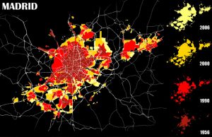
Applications: Town planning and management, Land use classification & analysis, Urban change detection, Property and Facilities Management Benefits: Rapid data collection, Reduced Field work & Visual interpretation, Clear visual results, Detailed information USERS: Private and Public Agencies, City planners, Territory and Sustainability Departments, Protection Authorities Previous Next High resolution Aerial photography and satellite images together … Continue reading Tools For City Planning and Change Detection Of Land Use Areas